Park nearby Parque Urb. Upis
Coronavirus disease (COVID-19) Situation
confirmed cases
4572667
deaths
222161
Peru
Park nearby Parque Urb. Upis
Parque Urb. Upis
Izcuchaca Perú
contacts phone
:
+51
Latitude:
-13.4650523
, Longitude:
-72.1454153
read more
nearest Park
Urb. Upis Park
Izcuchaca
Park
read more
461 m
Los Inocentes
Izcuchaca
Park
read more
2.306 km
Vivero de Anta
Peru
Park
read more
3.993 km
Plaza de Armas
Pucyura
Park
read more
12.701 km
Cementerio Jardines de la Luz
Cusco
Park
read more
12.713 km
Plaza de Armas
Chinchero
Park
read more
13.279 km
Action Valley Cusco
3S
Park
read more
13.409 km
Plaza de Chinchero
Chinchero
Park
read more
14.564 km
Hatun Punku
Maras
Park
read more
17.465 km
Plaza Manco I
Yucay
Park
read more
17.754 km
para niños
Urquillos
Park
read more
18.645 km
Plazoleta Santa Teresa
Siete Cuartones 372, Cusco
Park
read more
18.905 km
Plaza Mayor de Cusco
PLAZA MAYOR, CENTRO DE, Cusco
Park
read more
18.924 km
Amazon Volunteer | Ecological reserve Chontachaka
Mantas 117, Cusco
Park
read more
19.121 km
Plazoleta Jesús Lambarri
Sunturwasi 394, Cusco
Park
read more
19.324 km
Plaza San Blas
Cuesta de San Blas, Cusco
Park
read more
19.812 km
Parque Navarrete
Cusco
Park
read more
19.834 km
Zaguán del Cielo
Callejon Retiro 45, Cusco
Park
read more
20.368 km
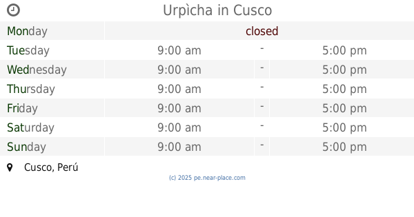
Urpìcha
Cusco
Park
read more
20.964 km
Plaza las Americas
Cusco
Park
read more
21.909 km
Parque Manuel Prado
Urbanización Manuel Prado, Cusco
Park
read more
23.365 km
Parque Y Loza De Los Licenciados
Naval 425, Cusco
Park
read more
23.365 km
Y Loza De Los Licenciados Park
Naval 425, Cusco
Park
read more
24.308 km
QUESERMAYO
Inicio Quesermayo
Park
read more
25.416 km
RECREATIVO DE LAS JOYAS "parque Onix" Park
Cusco
Park
read more
📑
all categories
Accounting
Administrative area level 1
Administrative area level 2
Airport
Amusement park
Aquarium
Art gallery
Atm
Bakery
Bank
Bar
Beauty salon
Bicycle store
Book store
Bowling alley
Bus station
Cafe
Campground
Car dealer
Car rental
Car repair
Car wash
Casino
Cemetery
Church
City hall
Clothing store
Colloquial area
Convenience store
Courthouse
Dentist
Department store
Doctor
Electrician
Electronics store
Embassy
Finance
Fire station
Florist
Food
Funeral home
Furniture store
Gas station
General contractor
Grocery or supermarket
Gym
Hair care
Hardware store
Health
Hindu Temple
Home goods store
Hospital
Insurance agency
Intersection
Jewelry store
Laundry
Lawyer
Library
Light rail station
Liquor store
Local government office
Locality
Locksmith
Lodging
Meal delivery
Meal takeaway
Mosque
Movie rental
Movie theater
Moving company
Museum
Natural feature
Neighborhood
Night club
Painter
Park
Parking
Pet store
Pharmacy
Physiotherapist
Place of worship
Plumber
Point of interest
Police
Political
Post office
Premise
Real estate agency
Restaurant
Roofing contractor
Route
Rv park, camping
School
Shoe store
Shopping mall
Spa
Stadium
Storage
Store
Subpremise
Subway station
Supermarket
Synagogue
Taxi stand
Train station
Transit station
Travel agency
University
Veterinary care
Zoo
administrative area level 3
sublocality level 1
↑