Restaurant nearby Hom
Peru
Restaurant nearby Hom
Hom
Calle G, Callao Perú
contacts phone
:
+51
Latitude:
-12.021405
, Longitude:
-77.1026816
read more
nearest Restaurant
87 m
Cevicheria Nanos'2
Avenida Tomas Valle, Callao
Restaurant
read more
149 m
Polleria Salazar
Callao District
Restaurant
read more
149 m
Polleria Salazar
Callao
Restaurant
read more
160 m
Polleria Zalasar
Unnamed Road, Callao
Restaurant
read more
170 m
Cabaña
Avenida Tomas Valle, Callao
Restaurant
read more
262 m
Sabor Peruano
Centro Aereo Comercial, Avenida Tomas Valle, Callao
Restaurant
read more
265 m
El Rincon de Tula
Avenida Elmer Faucett, Callao
Restaurant
read more
575 m
Restaurante MERY'S
Avenida Tomas Valle 107, Callao
Restaurant
read more
602 m
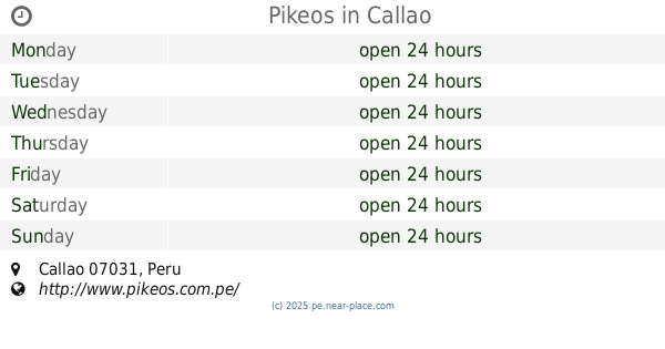
Pikeos
Callao District
Restaurant
read more
612 m
Pronto Cafe
District
Restaurant
read more
626 m
Restaurant Cevichería "Puro Norte"
Avenida Pacasmayo, Callao
Restaurant
read more
632 m
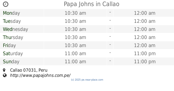
Papa Johns
Callao District
Restaurant
read more
665 m
Anticucheria Don Armando
Block 3, Calle Misionero Manzini, Callao
Restaurant
read more
670 m
Polleria Los Dorados
Pacasmayo, Callao
Restaurant
read more
684 m
Restaurant Camilita
Callao
Restaurant
read more
723 m
RESTAURANT CEVICHERIA PIERO'S
Paseo los Dominicos 228, Callao
Restaurant
read more
730 m
Saysiburguer
Callao District
Restaurant
read more
858 m
Bocadillo
Av Rosedal 304, Callao
Restaurant
read more
969 m
South Fish
Avenida Tomas Valle 3467, Callao
Restaurant
read more
1.033 km
Chifa Río
Cercado de Lima
Restaurant
read more
1.053 km
Sabores De Mi Tierra - Resto Bar
con, Av. Quilca & Calle 3, Callao
Restaurant
read more
1.073 km
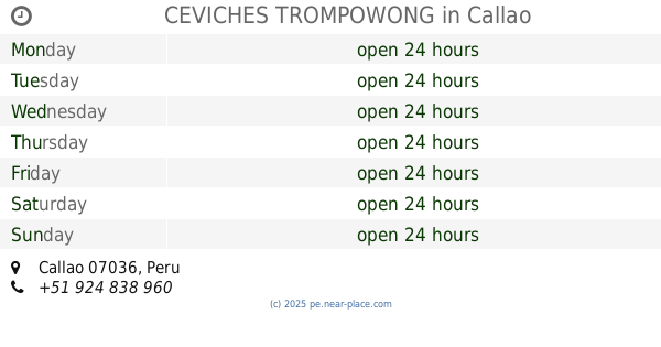
CEVICHES TROMPOWONG
Callao District
Restaurant
read more
1.154 km
Chinguirito De Luis
Avenida los Dominicos 583, Callao
Restaurant
read more
1.158 km
PIzza Raul Dominicos
Avenida los Dominicos 675, Callao
Restaurant
read more
1.348 km
Chifa Yong Hong
de, Avenida Perú 4160, San Martín de Porres
Restaurant
read more
📑
all categories
Accounting
Administrative area level 1
Administrative area level 2
Airport
Amusement park
Aquarium
Art gallery
Atm
Bakery
Bank
Bar
Beauty salon
Bicycle store
Book store
Bowling alley
Bus station
Cafe
Campground
Car dealer
Car rental
Car repair
Car wash
Casino
Cemetery
Church
City hall
Clothing store
Colloquial area
Convenience store
Courthouse
Dentist
Department store
Doctor
Electrician
Electronics store
Embassy
Finance
Fire station
Florist
Food
Funeral home
Furniture store
Gas station
General contractor
Grocery or supermarket
Gym
Hair care
Hardware store
Health
Hindu Temple
Home goods store
Hospital
Insurance agency
Intersection
Jewelry store
Laundry
Lawyer
Library
Light rail station
Liquor store
Local government office
Locality
Locksmith
Lodging
Meal delivery
Meal takeaway
Mosque
Movie rental
Movie theater
Moving company
Museum
Natural feature
Neighborhood
Night club
Painter
Park
Parking
Pet store
Pharmacy
Physiotherapist
Place of worship
Plumber
Point of interest
Police
Political
Post office
Premise
Real estate agency
Restaurant
Roofing contractor
Route
Rv park, camping
School
Shoe store
Shopping mall
Spa
Stadium
Storage
Store
Subpremise
Subway station
Supermarket
Synagogue
Taxi stand
Train station
Transit station
Travel agency
University
Veterinary care
Zoo
administrative area level 3
sublocality level 1
↑